Gravel driveway: survey
A gravel driveway: excavation, geotextile, base and surface gravel in cubic yards and tons, crown, slope and entrance culverts.
No credit card. Cancel anytime.
Feet and inches or metric: your choice. One switch on the sheet converts every measurement.
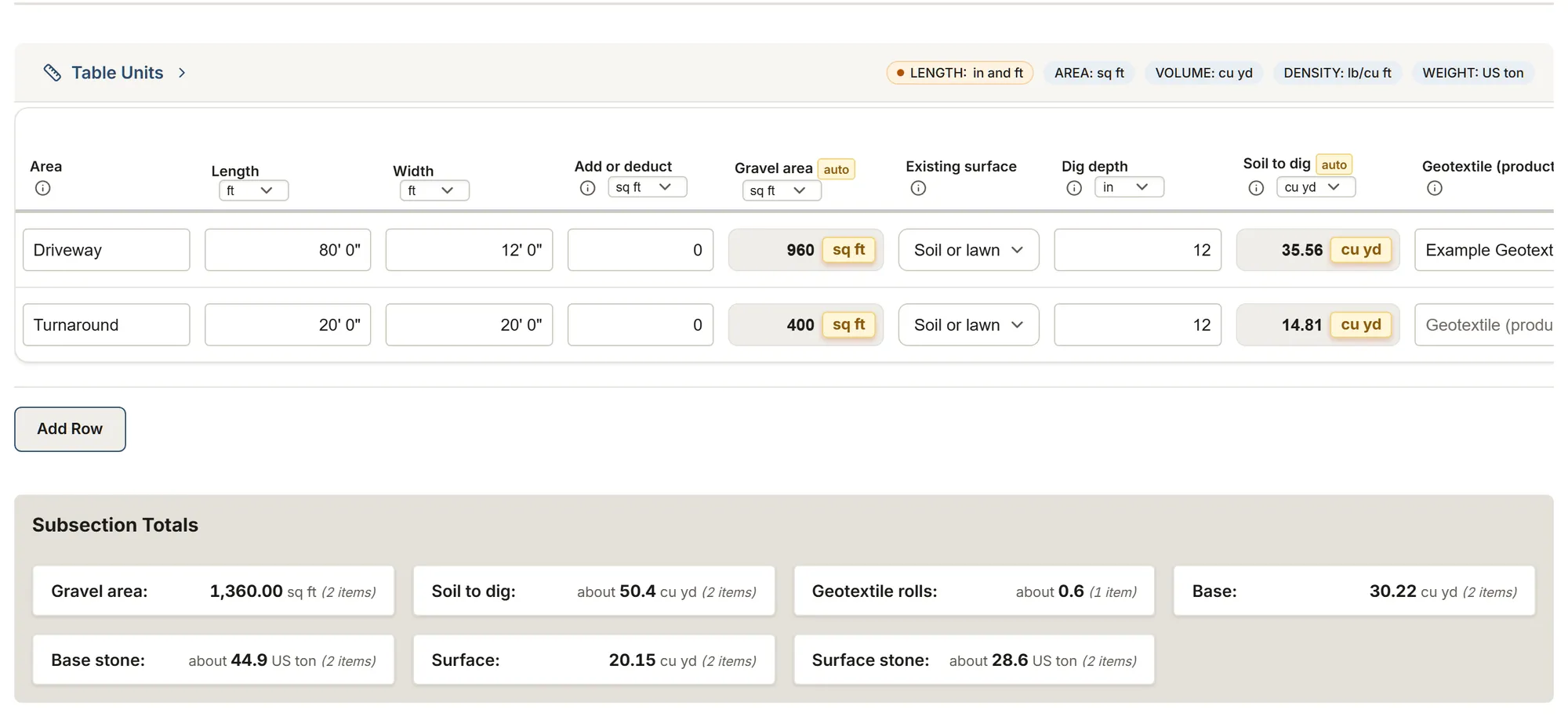
What you measure
The template's tables and their columns, as the app shows them. Calculated columns fill in as you type.
Gravel areas
- Area
- Length
- Width
- Add or deduct
- Gravel area calculated
- Existing surfaceChoices: Soil or lawn Old gravel Old asphalt Concrete
- Dig depth
- Soil to dig calculated
- Geotextile (product)
- Area per roll
- Overlap allowance
- Geotextile rolls calculated
- Base material
- Base depth
- Base allowance
- Base calculated
- Base density
- Base stone calculated
- Surface gravel
- Surface depth
- Surface allowance
- Surface calculated
- Surface density
- Surface stone calculated
- Crown
- Crown rise at the centre calculated
- Slope
- Fall over the length calculated
- Notes
Entrance culverts
- Location
- Culvert (product)
- MaterialChoices: HDPE Corrugated steel Concrete
- Diameter
- Culvert length
- Count
- Total length calculated
- Notes
About this template
Area by area: the gravel area, the soil to dig, the geotextile rolls, a base layer and a surface layer in cubic yards and tonnes per material from your quarry's density, the crown and the slope, and the entrance culverts.
Guide and sources
One row per gravel area: the length and width, with the curves added or taken out, give the gravel area. Type the dig depth below the finished surface: the sheet gives the soil to dig. Locate the lines before digging (Info-Excavation, 811). On clay or a soft subgrade, a geotextile (CAA-Québec, FHWA): type the roll's area and an allowance for the overlaps (NRCS Wisconsin: 24 in at least without sewing), and the sheet gives the rolls per product.
Two layers, each with its material, its compacted depth and an allowance for the loose stone (ToolGrit: 15 to 25%), in cubic yards, and in tonnes once you type your quarry's density; they add up per material and round up once. Lac-Sainte-Marie's 2022 tender prints 200 mm of MG 112 on its road and at least 150 mm of MG 20 to restore a private entrance; the FHWA lays more than 4 in in separate layers. The crown (FHWA: about 1/2 in per foot, 4%) gives the rise at the centre, the slope the fall over the length.
Where the driveway crosses a ditch, one row per entrance culvert: the product, its diameter and length as the municipality sets them (Lac-Sainte-Marie: HDPE, 450 mm by 6 m) and the count. Nothing comes filled in and nothing is priced. The client's report shows the areas, the soil to dig, the geotextile, the stone in tonnes and the culverts; the depths, densities, allowances, crown and slope stay in your team's report.
Sources
- 811 (US) Trade association
- FHWA, gravel roads guide (2015) Government
- NRCS Wisconsin, geotextiles (2022) Government
- ToolGrit, aggregate ordering Rule of thumb
- Shaker Heights, driveway requirements Government
- CAA-Québec, driveway paving Trade association
- Base stone suppliers Manufacturer data
- Info-Excavation Trade association
- Lac-Sainte-Marie, road tender (2022) Government
More templates: Sealcoating and striping
Sealcoating: site survey
Areas by use and condition, cracks, potholes and patches, oil spots; sealer, water, sand and pails for each coat.
You get: Area Sealant volume Sealant weight
Parking lot striping: survey
Stalls by type and angle, lines by kind and color, stencils, curbs and wheel stops, paint per color.
You get: Line length Line paint Stencil paint
Asphalt driveway paving: survey
A new asphalt driveway: excavation, base in cubic yards and tons, base and surface courses in tons per mix, slope.
You get: Paved area Soil to dig Base
Your trade isn't listed? The AI assistant builds your form.
Start your 14-day free trialNo credit card. Cancel anytime.